Sunday, July 29, 2012

Mount Audubon and Paiute Peak Loop from Brainard Lake

We've not lived long enough in Colorado to know what "normal" looks like, but the locals tell us that the weather this year has been most unusual. Only a few weeks ago in Boulder we experienced 11 consecutive 100+ degree days and every day bar 2 in July has been above 90. We drove 4 days across country in December 2010, arriving in Boulder as the first serious snowstorm of the year was underway. The locals said that was unusual. We finished that first winter with moderate accumulation figures in the town, but huge amounts of snow in the mountains. I recall last spring finding many of the high mountain trails out of action well into June.

This last winter was the reverse and we saw a lot of snow on the foothills and plains, but very little in the mountains. It has been evident all summer that this is problematic. But climate change, in the US, is a little like religion - despite the evidence, and despite the utter stupidity of some of the more extreme opinions, it is almost impossible to have a sensible debate. As Americans seriously consider electing a President who believes the "Garden of Eden" was in Missouri, the future for science and free enquiry isn't all that promising. And as for global warming...well, the huge amount of money being pumped into anti-science groups from big oil to wealthy individuals, tells you that this isn't going to be settled by the science. Despite the overwhelming evidence, denialism is taking hold.

It is therefore extremely encouraging that research is starting to change some skeptical minds.

http://www.guardian.co.uk/science/2012/jul/29/climate-change-sceptics-change-mind

With both dogs taking a break today I set off on my own from Brainard Lake. I had much bigger objectives that what I eventually achieved...but lived to run another day.


It was 46 degrees at the trailhead...pretty chilly...and I was toying with wearing a long-sleeved top. It was breezy without blowing a gale and although the wind would be stronger up high I figured the sun would compensate. Tee-shirt it was. There was a little sun poking through, but not very much, and although some rays lit up Mount Toll and Pawnee, I wasn't feeling the warmth at all and my clothing decision was already in doubt.


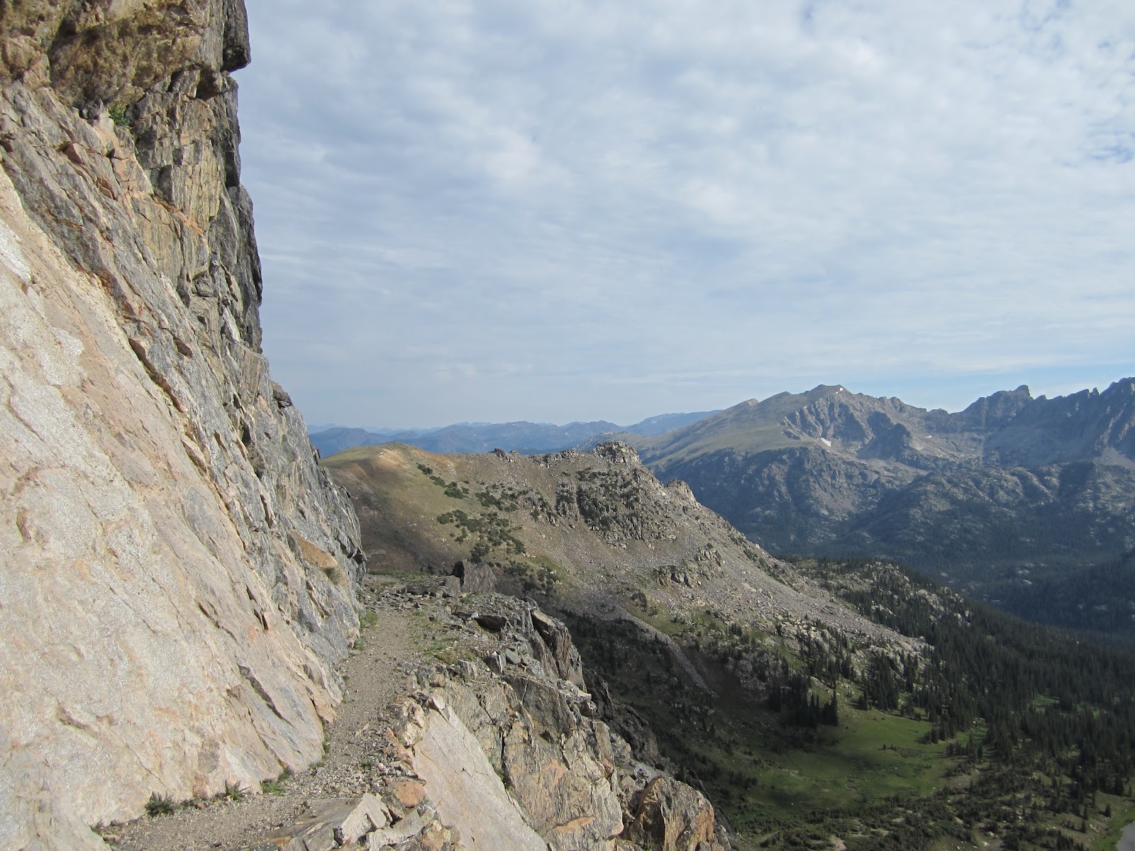
I knew the trail up Audubon from previous visits. It's not too steep to run, but it is really difficult underfoot. This wasn't helped by my choice of shoe - a brand new pair of Walsh Spirit Lights - and the creasing across the toe line was removing skin. They'll be fine in a few more weeks, but I grimaced through the developing soreness unaware that this would be the least of my problems. Just beyond the point in the photo above the trail swings west and Audubon comes into view. I could see a runner high on the switchbacks...a good mile and a half ahead of me. I wouldn't catch him, but it didn't stop me trying.


Just after taking this picture of the final ascent up Audubon the runner met me as he descended from the summit. We chatted for a few minutes - he had been "let out" for two hours on his own and would now have to race back to his car for a family event. How many of us find ourselves in this situation? Torn pleasures, sometimes conflicting, sometimes in balance.


Just below the summit the ridge to Paiute strikes out west. This would be new territory for me. I had always wanted to run this ridge but I didn't want to have a dog with me at the time. I knew there were many rocky steps and exposed scrambles and I didn't want to put the dogs under duress. I also knew that the final steep section up to the summit of Paiute was a bit loose and chossy...hardly the terrain for a dog. It was a wise decision.


It's a great view from the summit. Sawtooth is on the extreme right and in the valley below is Upper Coney Lake. I was really cold on the summit, but didn't want to stop and add layers. I don't know why. I hadn't seen much sun and my thermometer showed 38 degrees and probably 25 mph wind. Not exactly shorts and tee-shirt weather, but I can pretend to be tough when I want to be and started the descent to the Paiute ridge. Any thought that I would be jogging along this ridge quickly evaporated.


I've looked along this ridge a number of times from Audubon and every time I've thought...that looks a great run. Really? In the mile or so from summit to summit I probably ran for about 400yds at most, and even that was very tentative. It was just rough, loose and dangerous. I'll come to the danger bit in a moment. I was so thankful not to have a dog with me, and although I miss the company I felt pleased I got one decision right.

The main problem is that there isn't really a trail. There are some sections which show signs of passing...a few scratch marks on rocks...the odd worn patch of grass...but nothing obvious. I didn't mind that at all. I like to think ahead and evaluate routing options and I generally chose well. The descent from Audubon loses about 700 feet in altitude from 13,000 feet and gains about 600 feet on the climb up to Paiute. With both mountains above 13,000 feet this is a big trip. The imposing bulk of Paiute dominates.

With the goal in sight and most of the descent complete I relaxed a little and my boulder-hopping became a little more daring and faster. I don't know what caused this. Maybe I was concerned about the time. My plan had been to summit Audubon in 1hr 30 minutes and I was 5 minutes ahead of that time. But I had only allowed 30 minutes for the Paiute ridge and I could sense it taking longer. It's in these moments...perceptions based on flawed judgments...that can distract and cause accidents. I was annoyingly thinking of this when I leaped onto a large and solid looking boulder. It shifted under my weight and I fell in a gentle arc. The sound of my knee crunching into an oncoming rock was for my ears only and the sudden flush of nausea demanded I sit down immediately. The excruciating, searing pain was short-lived. Surprisingly there was no blood, just a dark patch where the internal bleeding spread. 

I was lucky...and I knew it. My head cleared, I stood up, dusted myself down and headed off again. A little gingerly at first but then more purposefully. As I ascended Paiute I could feel a little light-headed. Now, normally I would make some kind of self-deprecating comment about my brain power and general dimwittedness, but this was a bit more serious. I sensed low blood sugar and knew I had to reach the summit and take in some fuel.


I was glad I made it. A handful of nuts and some dried apricot did the trick and I appreciated the surroundings. To my earlier point on global warming, there is abundant visual evidence of serious climactic change. NCAR monitors glaciers in the area and there is concern that they are receding. I don't have sufficient reference points to know for sure, but the lack of a significant snowpack looks concerning. There's a summit register on Paiute (I've never found the one on Audubon) so I signed it...well, I tried to. My hands were so cold I could barely hold the pen. I managed a few illegible scribbles, screwed the lid on the tube and set off towards Mount Toll which was dominating the view south.

It was decision time. I'd lost too much time. After being 5 minutes ahead on Audubon, I was 7 minutes behind on Paiute. My knee was burning a little. The climb up Mount Toll would be challenging and then there was Pawnee Mountain beyond, followed by a descent of Pawnee pass on a busy trail. I descended to a col, down a few very steep steps, and evaluated my options. To complete my circuit I'd add another 4 miles to my overall mileage. If I descended to Blue lake there would be tricky talus to cover but I could pick up the Mitchell trail. I estimated 1hr 40 minutes down the Mitchell trail and 2hrs 30 down the Pawnee trail. Weighed in these terms there was really only one option and I began the descent to Blue lake.


Blue Lake is in a stunning glacial valley with Pawnee Peak on the right (south) and Audubon on the left. Lower down the valley I would skirt Mitchell lake on its southern shore and then get back to Brainard 2 miles beyond.


What's not to like about Mount Toll? This would have to wait for another trip. I descended to the point on the ridge just above the small snow field - it was actually a fairly big snow field but it is concealed behind a hidden ridge. I struck straight down the talus towards Blue Lake.


Across the valley to the south was Upper Blue Lake beneath the slopes of Audubon.


I'll have to return to Blue Lake with my wife. This is a great short hike destination.


It was a long, slow descent. Mount Toll is above my left shoulder. The small snow field in the upper right is the one that marked my descent for the ridge. I would be back, for sure.

I struck a faster pace down the trail to the car. There were quite a few walkers and hikers but I was surprised there weren't more. The sun was now out and the temperature was a pleasant 63 degrees. Back home it would be 95. This was a great outing. A few days of rest for my knee and I'll be back on the trails in no time.

South Arapaho Peak from Rainbow Lakes

It's getting to the point where little virgin territory remains. So prolific has been our focus that there aren't any more trailheads left to visit...at least on the east of the Divide and I am now looking at different trails up mountains already visited. This is hardly a burden. I have so many duplicate photos of the same views from the same mountains but on different days, revealing the pleasure of a beautiful view revisited. I'll never tire of the aesthetic pleasure. There's a chapter in Emile Zola's "La Debacle" that describes an industrial northern French town at the fall of the third republic - I just have to conjure that description to truly appreciate the majesty of the Indian Peaks.

I was tired for lots of reasons. Not just the flight delays and cancelations as I criss-crossed the country during my working week, and I set an aggressive alarm clock with the thought that, come morning, I would be raring to go. It didn't quite work out that way and only a morning "wash" from Livvy kept me from turning over. But even she was lethargic. It took her a good 5 minutes before she could drag herself to her breakfast. We were the antithesis of the athletic specimen. The thought of running from the only trailhead I had yet to visit was all that motivated me. It would all change when we got underway.

I'm not sure what I think about allwheel-drive off-roading. I've tried to think it through but the pictures that form in my mind are very negative and almost certainly biased. I think it's the idea of man-made machines gouging up the countryside with their physical and aural pollution that is at the heart of my disquiet. This came home to me a few weeks ago when the solitude was shattered by a revving engine and shouted expletives at Coney Flats...a favorite off-road trip. Because open space is so limited in the UK I used to get very upset when off-road motor cyclists ripped up the trails illegally and caused untold damage. It was the attitude of disrespect of the environment that troubled me the most, which started with littering at one end and physical damage to the earth's surface at the other. I just had it in my head that no self-respecting person who cared for the environment would accelerate its demise.

But life is full of unhelpful contradictions. I drive a car, for example, and there was little doubt that doing so was damaging the environment. I would buy products sold in non-biodegradable wrapping without a second thought. We are all guilty in so many different ways.

My distraction with off-road driving was prompted on the way to Rainbow Lakes trailhead. Shortly before reaching the parking spot there is a large sign pointing to an off-road driving course. The entrance to this area was littered with...well, litter. Soda cans, plastic bags...all discarded without a thought for the environment. It was a mess. I saw the same mess every time I drove by the entrance to the off-road course on Lefthand Canyon (where the careless discarding of a cigarette ignited a major fire that threatened life and home last year). Similarly, Camp Dick (there's that name again), where the loop through Coney Flats commences. While I am the first to point out that anecdote doesn't equal data, my three reference points correlated. Maybe I am generally negative about off-road driving less because of the environmental harm that it causes and more because of the kind of people I believe do it. The word to describe this is "prejudice" and it's difficult to face when it stares back at you from the mirror.

It looked as though a couple of cars at the trailhead were recent arrivals and this meant folk ahead on the trail. Oh well, it was a nice cool morning and the previous night's thunderstorm was evident around us. We set off up the Arapaho Glacier trail...another annoying trail that undulates for 2.5 miles without much appreciable gain in altitude. I knew we had over 3,800 feet of climbing ahead so it must come soon.


We emerged from the treeline and the trail switch-backed up the grassy flanks of an unnamed mound ahead. We were running the whole way, taking a breather on the steeper sections. As the sun rose the temperature picked up and it made the tee-shirt selection at least look reasonable. Up ahead I caught sight of a runner, clearly going a little slower than us. This would be our first target.


It's funny, but sometimes the psychology of a situation overrides all common sense. The runner saw us from a distance. As soon as I knew he had seen us I knew we would catch him quickly. His brain told him to speed up and I could see him step out a little quicker. But Livvy and I just kept plodding at the same pace. The runner ahead raised his effort too much and the rebound exhausted him. I was once told by a wily competitor, many years ago, that the time to accelerate is when you pass someone...not before. His theory (and it always worked) was that the person in front of you was already working hard to keep ahead and that accelerating hard past them would prevent them dropping in your slipstream and getting a "tow". I can barely believe I took the trouble to explain that. If the runner in front was a snail, then I was a slightly faster snail. But it still felt good to power (ahem!) by someone who looked 30 years my younger.


The high level contour that would lead to Arapaho Pass was great running ground. Verdant and exposed with only the occasional rocky section. There were several raised stones pointing the way (as if these were needed in the summer) and we crossed several sparklingly clear ponds...the product of overnight rain. In the distance you can see Mount Neva and just left of center is Diamond Lake.


As we rounded a shoulder, South Arapaho Peak came into view. Livvy and I had only been here a few weeks ago, but this was a much longer approach. Down to our left we could see a lot of hikers coming up the route we last took from the 4th July trailhead. If we picked up our pace we'd get to the final steep climb before them and prevent being held up.


Climbing up the southern flank of South Arapaho we got this stunning view of Lake Dorothy and Mount Neva. The Caribou trail skirts the lake before heading off west. Livvy and I were on that trail a few weeks ago heading for Santanta Mountain.

Approaching the foot of the final, brutal climb we could see a party of three high up on the skyline. I wonder? We passed them about 100 feet below the top in another Neanderthal display of thinking. I collapsed at the summit drawing deep breaths, immensely proud of this non-achievement.


Descending the way we had climbed we could see hikers gathering at the pass and the trail home was clearly visible. Far below to the right the 4th of July trailhead can be seen in the valley. Only 4.5 miles if we were going there, but Rainbow lakes was 6.5 miles away.


A mile away we could see Rainbow Lakes and another 2.5 miles to the trailhead. As we approached the parking lot we met a couple with a small dog. "How big is the glacier?" I knew this wasn't the question they wanted answered. "How far is it?" That's more like it. "You've got about 6 miles and it's all uphill". "How far are the Rainbow Lakes?" "Oh, they're only about 10 minutes" "Let's head there instead dear".

It's decisions like these, made every day, that make trail running such fun.

Saturday, July 28, 2012

Introducing Andrew

Americans don't really have a class system. They talk about it, and they throw a few labels around - like "middle class" - but you know the second they finish speaking that they don't know the first thing about a class system. America has rich people, and they have poor people, but they don't do "class" well at all.

The British, on the other hand, are masters at the class system. Not only do they do it well, not only has it survived egalitarian policy making and educational advancements, but it has been in existence forever. I should, perhaps, be more specific and state that it is the English in particular who have both crafted and mastered the class system, for fear of offending my Scot, Irish and Welsh friends, where the issues I'll highlight are less well developed...except around Balmoral when Queenie is in town. So whereas the American class system, for what it's worth, is a brash economic model, the English class system drips with indicators at many levels, from accent, to school, to neighborhood, to the friends you keep and the places you go. The "old school tie" has greater currency value than a greenback.

In the 18th and 19th centuries the English working class, when they weren't dying in their hundreds and thousands in coal mines and factories, used to make ends meet by poaching on the estates of the upper class. Rabbits, pheasant, fish, deer - whatever could be caught by snare or stealth was caught and consumed. It was risk in combat with gamekeepers that didn't always turn in their favor. Potential starvation made the risk acceptable. There were two main types of dog that would accompany a poacher - either a terrier, excellent for going down holes and killing animals, or a lurcher. A lurcher was a sight hound that, once unleashed, would run down a target before killing it. They were fast over short bursts.

It was my wife who first posed the question. I remember it well. It was a warm, late summer afternoon - I had just returned from work and she had been...well, we'll come to that shortly. We already had a dog. Jet was, well, black. Our son Thomas had selected her from a litter at the animal rescue and I took some persuading even on this request. But Jet arrived and the matter was settled. Our family was complete. We had a beautiful old house in the moorland hills of northern England, 2 children and a dog. What more could we want?

My wife clearly had other ideas. On the day in question she carefully wrote "gullible mug" on her forehead and went to the animal rescue center, apparently speculatively. I have my doubts and there was a strong whiff of premeditation. When all the facts eventually came out much later she admitted to seeing a half-page ad in the local paper and when she saw the photo and read the story she just had to "go and see".

Andrew was an English Lurcher. The moment I saw his photo I knew he'd be trouble. He constantly looked as though he was about to commit a crime...or had just committed a crime...and he was definitely guilty. In truth, his story was miserable, and it was this that softened my uncompromising refusal. As a pup he had been mistreated. He was then abandoned and was hit by a car on the highway and left for dead. He was found and taken to a veterinary surgery where he underwent a number of serious operations the outcome of which saw him with screws, metal pieces and splints in his forelegs. Speaking purely personally, I'm not entirely sure his brain wasn't damaged as well, although my wife moves quickly to silence me on that point.

I can't remember how long I held out. The barrage was relentless. Every night like clockwork a constant stream of ridiculous suggestions would usher across the room. "Let's just try him for a weekend", "Some nasty person might take him and abuse him again", "He's be great company for Jet and Jet is lonely". I looked at Jet sleeping comfortably by the fire. She didn't look too troubled to me. And then, in what must have been only a momentary lapse, I let my guard down and said something vaguely possibilistic. Two days later Andrew arrived "on trial". Now, "on trial" meant something very different to me that it did to my wife and kids. For me it was clear. We keep him for a few days, send him back...and then talk about it. But what it really meant was...he's here for good unless he rips down the house brick by brick, eats three neighborhood children and savages the postman (although on this last point I could see some merit).


The rest, they say, is history and over the next few months I'll explain what happened with Andrew, what he got up to, and how he became such an amazing dog. He was also hilarious despite the fact that he only used his brain cells in pairs...which meant that all four of them were soon completely worn out.


Friday, July 27, 2012

Nittany Mountain

Musings on Penn State, the Tour de France, happiness and depression

In my defense, and I should state this upfront, this has not been the best time for clear thinking. In mitigation I could and will cite the reasons, but for now I want to describe a trail I ran today against the backdrop of some emotionally wrenching, uplifting and conflicting events. Nittany Mountain in State College, PA isn't on anyone's tick list. It doesn't make it on the list of "50 mountains I must climb before I die". At its highest point it doesn't reach the lowest elevation of my home state in Colorado. And while it is not going to be swamped by the sea as a result of global warming, it isn't what you would call "imposing". But I was here for other reasons that I'll come to shortly.

Of course, it is impossible to drive into State College, as I did on a beautiful afternoon yesterday, and not be struck by the fall from grace of such a venerable educational institution as Penn State. Even the road signs bearing the name seemed to drip with shame. The egregious ethical lapse at the heart of this demise is difficult to fathom. I have always been suspicious of those who have statues built of them in their lifetime (isn't this the prerogative of despots and dictators?) and the very recent removal of THAT statue from Beaver Stadium while symbolic, hardly addresses the issues it came to personify. 

As I set out running from my hotel towards Nittany Mountain these thoughts were swirling around my head. A dark and threatening sky had replaced the clear blue of yesterday and I wasn't in a mood to pay much attention to my watch. But it was 6am. There was no traffic, no human activity of any kind that I could see. The thunder rumbled just as I left the road and hit the first section of trail. I had barely broken sweat.

Yet the recent weekend had been a cause for such optimism. The greatest sporting event in the world - the Tour de France - had reached its climax in Paris and crowned Bradley Wiggins as the first ever UK victor. But it wasn't the fact of his victory that caused me to think of him this morning. It was the contrasting juxtaposition of perspectives on ethical conduct coming from a professional cyclist (where sadly we have come to least expect it) compared to a high standing educational institution (where we just assume it). Wiggins was inevitably asked about doping and the question, although understandable, clearly annoyed him. His response was a devastating statement of personal, moral integrity, responsibility and value. "The question that needs to be asked is not why I wouldn't take drugs, but why would I? I know exactly why I wouldn't dope...If I doped I would potentially stand to lose everything. It's a long list. My reputation, my livelihood, my marriage, my family, my house. Everything I have achieved, my Olympic medals, my world titles, the CBE I was given. I would have to take my children to the school gates...with everyone looking at me, knowing I had cheated, knowing I had, perhaps, won the Tour de France, but then been caught."

I reflected on this contrast as I climbed the initial blue trail as it contoured to the north east before pulling more steeply to crest the ridge after a mile. The oppressive weather fomented dark thoughts and I became annoyed at the skewed moral relativism of Messrs Spanier, Paterno, and Sandusky (and how many others were still waiting to be discovered?).  From those whose ethical values we took for granted we saw many innocents suffer, and from a sport (cycling) so long clothed with a "dirty" label we received a searing definition of the very essence of ethical conduct. It played in my mind for a while. The great, late manager of Liverpool football (soccer) club in the UK - Bill Shankly - once said that "Football wasn't an issue of life or death...it was much more important than that." It was an amusing retort and understandable in the proper context. It is so unfortunate that those who should have known better at Penn State allowed this statement to define their very existence, their ultimate sense of distorted value.

I had forgotten how humid and sticky the weather can be close to the east coast. I had also forgotten the insects. As I slowed down when the trail steepened I was pestered by a large fly attempting to sample the haemaglobin quality in my left leg. I swatted it away several times but it kept coming back. At least I thought it kept coming back. After all, I am sure there was more than one fly in the vicinity. But I needed something specific to dislike at that particular moment and in no time, not only had this fly developed a personality, it also came to represent everything that I detested. I did what every human does, I gave this fly anthropomorphic qualities and then allowed my competitive instinct to do the rest. I flew up the final section of the steepest part of the trail in a barely concealed inner rage. I had completed the first 3 miles at a leisurely pace yet did this last half mile propelled like a dervish. My stupidity knew no bounds and the shallow satisfaction of beating the fly gave way to inner embarrassment which thankfully, no-one witnessed, and I resumed a more reasonable gait.

For all of Nittany Mountain's insignificance it does provide for some pretty vistas of the surrounding area. One overlook towers above Beaver Stadium. While pausing and reflecting again the rain came like stair rods and it crossed my mind that this wasn't the best place to be with lightening flickering in the distance. Later in the day, when driving by Beaver Stadium, I saw the habitual nutcase bearing a sign proclaiming recent events to be the product of God's wrath with repentance the solution. Well, if repentance wasn't enough to prevent the incidents of shame I failed to see how it would be the solution. I recalled the then Pope - John Paul 2 - who bestowed papal credit for him surviving a shooting attack on Our Lady of Fatima, a somewhat obscure nun who apparently prostrated herself and prayed in a manner that he believed caused his survival. If she was so much more effective than modern medicine in curing him, why hadn't she prevented the bullet hitting him in the first place? I am sure the victims of this abuse find total relief and release from this kind of posturing.

If the Nittany trail is completely runnable this doesn't mean it is uniformly easy. Once I had completed the 5 mile circuit of the Blue trail my auto-pilot steered me to the White trail for another 3 miles. This brought even rockier terrain - not exactly South Arapaho Peak rocky, but maybe Mount Sanitas rocky. It was good fun and the new ground opened up different outlooks across this sad community. Returning to the main trail junction I felt I had to make a conscious decision to return to the hotel otherwise, so lost in my thoughts,  I'd have kept running in circles all day. I had good reason. What bizarre circumstances had created this emotional confusion?

I hate redeye flights. The previous day, evening, night and morning had been swallowed by an unsatisfactory flight from San Francisco to Newark. 6 hours of hell. The arriving east coast dawn failed to lift my spirit and the anticipation of a long day on such little sleep asserted its influence. Verizon 3G connects and the phone and email messages start to click in. And then a text. Texts come from family. It's just how it is. Work is email, family is text. I always read texts first, but this came when everyone should be sleeping. I could then see it was from the UK. I scanned it quickly as the body blow floored me and I had to sit down and process my thoughts. I don't express emotions. It's more than a "guy" thing. I have feelings, but for the most part they are deliberately suppressed and I am able to fool those around me with a superficial confidence that is difficult to penetrate. I am called "cold" and "intense" for good reason. At work it's a strength, at home it's a weakness. Or maybe I'm just deluding myself and it's a weakness, period.

This all came flooding back as I pushed myself at a silly pace back along the road to the hotel. The rain was streaming down. I was soaked to the skin. Mist, cloud, thunder and rain concealed the hurt. But it was deep and visceral. It was barely contained.

We knew this was going to happen but it didn't make it any easier. When such a good friend is lost to cancer foreknowledge enables a certain poise to be practiced but never mastered. And I try to look at these situations positively. As Richard Dawkins wrote in "Unweaving the Rainbow", "We are going to die, and that makes us the lucky ones. Most people are never going to die because they are never going to be born." As brutal as this sounds it represents a truth that forces us to be thankful...thankful that someone like David was born and lived and thankful that we got to share the same space and time. 

More reflection. Only a week ago I got to spend a wonderful evening with my daughter on her birthday in San Francisco and today I was spending time with my son on his birthday in State College. Sandwiched between them in age is David's daughter...their friend...a person they grew up with and shared so much. This mixture of uplifting and depressing emotions were processed by my brain in simultaneous accord. I could never understand why, as a child, my father would express his pride of my brother and I. I couldn't see what we had done to deserve this. When I was very young I just didn't understand, when I was a teenager it just felt awkward. It is only as a parent that I truly came to appreciate that he expressed a feeling that was so important to him. As I look at Amy and Tom as young adults, facing the world and making their own decisions it makes me feel my wife and I did some things right just as my own parents had with us. My father was right to be proud and I, in turn, couldn't be prouder of my kids.

And this is what brought me to the slopes of Nittany Mountain. It explains a roller coaster of emotions from such great happiness to depression, from anger to hope and it played out against a environment that seemed to want to intervene have its influence. As I flew out of State College I looked down on Happy Valley. It's a current misnomer, but it is a valley that has some reason to feel happy.

Sunday, July 22, 2012

Mount Audubon

I never knew "free access" days existed in the National Parks and I was lucky to catch one on the day I decided to run the Mount Audubon trail. Access to the Brainard Lake trailhead usually costs all of $9, but when I arrived at 5am there was no-one in sight at the gate and there was no manual payment system visible. I was confused at first but my rationale...and defense...was that I could always pay on exit. I drove up the access road and parked up...the only vehicle in the lot. It was a mild morning and the sun wasn't yet up. Otto was lively and we headed off through the woods in pretty dark conditions.

The first section of this trail is fairly level and although a few "hidden" tree roots did their best to trip me up I managed to emerge from the treeline and into the dawn reasonably unscathed. It's here that the trail gets rocky and steep and the switchbacks up the southeastern slopes of the mountain kick in.

Audubon isn't a long trail...about 9 miles roundtrip...but it reaches above 13,000 feet. It also isn't the most visually appealing mountain. There are no steep cliffs, no knife edge ridge, no exposed summit perch. It's a bit like the upturned hull of a boat, or maybe the back of a whale. I know that appearances from a distance can be deceptive and in the case of Audubon the deception comes in the running surface, because what looks to be green and accessible is actually extremely rocky and hard going.


This photo was taken after completion of our run. The trail skirts below the Krummholz on the right and heads behind the ridge on the cliff line to emerge on the summit from the North.


As the sun came up we were done stumbling through the dark and were able to step out a bit more briskly. This photo shows how challenging it is under foot. It's a good job I like to run more isolated trails at times when there are going to be few or no hikers around. Stumbling over rocks, stubbing my toe and twisting my ankle doesn't seem to enhance my vocabulary - these are not words to be teaching a dog. Otto runs ahead oblivious to my frustrations.

He becomes alert long before I see the cause. Otto is a very demonstrative dog and he stands bold and raises his ears slightly when something of interest is in sight. Of course, what is visible to Otto isn't necessarily visible to me...at least not yet. Borzoi are sight hounds and although they like to sniff and smell as much as any dog, they are bred to chase down visible prey. This makes any visible distraction a potential target regardless of distance. Otto's excellent eyesight picked up a herd of Elk.


Otto fixes his sight but I can't see anything. The early morning sun lacks clarity and it takes some time and closer proximity for me to detect what Otto could see.


A large herd of Elk move below the skyline and crest the ridge.

Another characteristic trait of Otto's is his single ear alert sign. This isn't the result of him seeing anything in particular. It really works like radar - it is on most of the time when he thinks he might hear something interesting. From the point of seeing those Elk Otto's radar was on.


Sure enough, after a short distance Otto detected a breeding pair of Ptarmigan and he waits and then looks for my approval to chase and then disembowel them. That's the thing about Borzoi...you just can't let them off leash, at any time in an open space. It's not that they won't return...eventually...it's that they are impossible to distract from their prey. They will run and run to chase down whatever is their fancy and, possibly 4 or 5 miles later remember that they were supposed to be doing something somewhere else.

I often look at all those green tagged dogs from the greater Boulder area...you know, the ones who have passed their obedience and close control (off leash) tests. This "license to roam" off leash is a coveted privilege...too often abused in my view...but it is a privilege no Borzoi will ever experience. But this is hardly a major problem. After all, which dogs get the chance to run and run for miles with their owner in such beautiful open country. Both Otto and Olivia enjoy supreme fitness that will add longevity and vitality - a leash is an enabler of that goal.


The view from the summit of Audubon to Longs Peak is amazing. In the early morning light the profile of the RMNP is brought into stunning clarity. In the center left of this photo is Sawtooth with the cliffs on its south face clearly visible. Across the valley to the right is St Vrain mountain - both summits we have visited.


The view south is dominated by the elegant profile of Mount Toll and a distant view of North Arapaho peak. The Indian Peaks really are, in my view, much more beautiful than those in the RMNP. And they also allow dogs...but don't get me started again.


The initial descent from the summit covers some steep, rocky steps and when the main trail eventually swings east it is possible to run at a very quick pace. It was towards the bottom of this section that we met our first hikers - a couple who had camped the previous night at Coney Flats and had taken the slightly longer route up Audubon. Rather than use a map they were struggling with a brand new GPS unit and requested my guidance. When I checked the unit the mistake was obvious - they were using the base map and hadn't uploaded the appropriate topo map. Consequently, none of the territory they were walking on was showing up - this map might be great for getting from Estes Park to Lyons, but it was useless for mountain trails. I gave them my single sheet printed map, pointed out the route and then ran off into the heat of the morning. They were a really nice couple and I'm glad they made their mistake in such clear weather on such a forgiving mountain. They would enjoy a great day and then later sell their GPS on eBay.


The final switchback on the descent revealed a view that had been concealed in the darkness of pre-dawn. Looking up the valley we could see Mount Toll and also catch the western fringe of Brainard Lake.

I must look for another one of those free access days...the trip up Pawnee looks outstanding!!

Tuesday, July 17, 2012

Sheep Mountain

Creationist Vandalism

I discovered Sheep Mountain during the winter months when scouring maps looking for an alternative to the low level mountains around Boulder. When the high mountains are out of action there are only so many times in succession that I can run up Green Mountain or South Boulder Peak before I need a change of scenery. The Big Thompson River gorge, west of Loveland, provides some good alternate running trails and although Sheep Mountain isn't a high elevation (8,450 feet) this makes it an ideal winter running route. But the dense woodland through to the summit also makes it a good venue for a shorter morning run in the summer when I don't have time for a high mountain outing.

The granite rocks that encase the Big Thompson canyon were formed underground over 3bn years ago. Subsequent glacial events and the action of water over time have carved through this granite to create an amazing environment. We see this kind of event all over the world on varying scales and in all kinds of rock, from the Grand Canyon to the Gorges du Verdon in the south of France. Although not a geologist I always take an acute interest in my environment and I am fascinated at the precision with which modern science has been able to determine the age and formation of such impressive rock structures.

Scientifically speaking, the age of these rocks isn't in any doubt. There isn't a debate taking place anywhere among serious scientists about how old these rocks are. The issue is what we call "settled". And the reason is evident. Radiometric dating is incredibly accurate and isotopic measurement extremely reliable. The principle is easy to grasp - we know, for example, the half-life of Potassium and how long it takes for this unstable substance to form Argon. This isn't a guess but a precise, reliable and stable calculation. It's accurate not just because it is testable, but that it has been tested. By calculating how much Potassium and Argon is present in rock we know how old it must be. Potassium/Argon isn't the only "clock" scientists use. We also know the decay rates of Uranium to Lead, Samarium to Neodymium, Rubidium to Strontium, Uranium to Thorium, Carbon 14 to Carbon. While the reliability of these clocks is extremely strong there is also consilience between them, and between them and other dating mechanisms like Fission Tracking, Chlorine-36 along with the more rudimentary methodologies like ice cores and dendrochronology. These dating methodologies all measure to different clocks over different timescales and they all agree.  (http://en.wikipedia.org/wiki/Radiometric_dating)

Back to Sheep Mountain. This is really a splendid trail...out and back. Although quite steep in places it is possible to maintain a pretty good pace, particularly over the initial mile and also in the section prior to the final climb. I have run this route with both Otto and Olivia on many occasions. The Park Service has done a great job of maintaining this trail and has also made it more interesting, informative and educational by providing small information boards at key points of interest along the trail. It is possible to find out about the flora and fauna as well as historical details describing human activity in the area over time. One of the information boards mentions that the rocks in the area were formed billions of years ago. This is true and is not an issue of debate or disagreement. How disgusting then that on my last visit, I discover the sign has been vandalized and "billions" has been struck out and "thousands" scratched in its place.


We know a lot about the kind of person who did this and what they stand for. It is nothing short of a national disgrace that the ignorance exemplified by this behavior is seen by some as a point of virtue. While people are entitled to their own opinions, they are not entitled to their own facts and the earth is not 6,000 years old however much they might wish it was. The irony is that these same individuals, who also claim that morality is "God-given" see no problem in carrying out criminal acts of vandalism in the name of Jesus.

A number of years ago I recall reading with some interest the silly attempts being made by Creationists to position their book on a 6,000 yr old Grand Canyon (caused by a single global flood no less) alongside serious science books on display at the National Park bookstore - http://www.agiweb.org/gap/evolution/AZ.html - and it was clear that their confrontational "free speech" claims were scaring legislators. But this isn't a free speech issue. Science isn't decided by claim and counter claim, it is decided by evidence and testing.

The creeping sickness of creationism is now spreading to the UK. Only a few weeks ago we read reports that the National Trust (a once venerable institution) has included an "alternative" explanation of the age of rocks at the Giant's Causeway in Northern Ireland as a result of demands from Creationists - http://www.museumsassociation.org/museums-journal/news/11072012-controversy-over-creationism-at-giants-causeway .

As we gather speed in the headlong rush to ignorance we have to ask ourselves whether alchemy has anything to contribute to Organic Chemistry, whether the "stork theory" is an acceptable explanation of child birth and whether pixies and fairies really are painting that rainbow you see in front of you. The fact that a sizable proportion of the US population is watching the Flintstones and assuming it is a documentary is something that should shame us all. And if there are any Creationists out there reading this, and thinking of visiting Sheep Mountain, please abide by the law, respect the countryside and those who have made it accessible to others, and, in doing so, stand back and admire the geological and evolutionary timescale that has created it. It's a far more inspirational story than a pathetic act of magic.

Monday, July 16, 2012

Mountain Running Shoes

A personal view

Back in the day, amongst the UK fell running community, there was only one name in mountain running shoe - Norman Walsh. It seems funny these days, with so much $bn brand hype that this cobbler from Bolton, Lancashire, who hand made running shoes to order should be so revered. If you didn't own a pair of "Walshes" you weren't in the game. English and British fell running champions alike all wore Walshes.

It seems that every sport promotes unwritten standards for acceptable participation. Whether for safety - kernmantle rather than hemp rope for climbing - or performance - carbon fiber skis rather than wood - breakthrough technologies sponsored by early adopters make a compelling visual appeal. The 1960's UK fell running crowd adopted Walshes, and for very good reason. Norman made them on a last that provided such a good general fit. Even after manufacturing processes were automated the shoes, although never as good as the hand made variety, were a pleasure to wear.

Before the emergence of modern specialty running shoe manufacturing, when companies like Addidas and Nike were in their infancy, Walsh had the complete market. And it was a fairly small market with the total participant field numbering in the hundreds rather than thousands. Lacking any incentive to get involved these larger companies ceded considerable brand positioning to Walsh and they became not only the default brand but the pre-eminent one.

Not surprisingly, as a young athlete in the late 1960's and early 1970's I owned Walsh fell shoes. I loved them. The distinctive pyramid studded soles seemed a perfect solution to the wet and boggy moorland and fellscape of Northern England where I lived. And they lasted for ages. With the current fad for "barefoot" running epitomized by Merrell Trailgloves, Walsh were already cut-down and low profile with a very small heel height. They were lightweight before lightweight became a trend. The big revolution came when Walsh brought out a second type of shoe specifically designed for training on mixed terrain and rocky trails where the need for heavy studding was less pronounced. This doubled their market for many runners could see sense in having a shoe more suited to certain kinds of terrain. I certainly bought a pair.

http://www.walshsports.com/index.html

During the late 80's and 90's I drifted in and out of fell running and the explosion of products designed for the outdoors passed me by. When I did venture out I had my Walshes and didn't really consider other options. When I left the UK in 2001 and moved to the US I just brought them with me. But Maryland isn't exactly an off-roader's paradise and apart from the odd weekend on the Appalachian Trail my Walshes gathered dust. When I took up serious running again in Colorado I naturally bought more Walsh shoes from my friends at Pete Bland Sports in Kendal, UK (www.peteblandsports.co.uk). But this is expensive for shipping and I have also accumulated designated off-road shoes from other manufacturers to complement my Walshes...or usually to wear while my Walshes are drying out from a recent run. The list is hardly extensive...

La Sportiva Crosslite 2.0
Salomon Fellcross
Montrail Bajada
Merrell Chameleon
North Face Double Track

Walsh PB Trainer

There are things about each of these shoes that I like, but none match the allround performance of my Walsh shoes. I like the Crosslite's grip but feel they sit too high and my ankle rolls on uneven ground. I really like the Fellcross but the fit is too narrow and they are punishing over longer distances. I like the Bajada for smooth trails but find the tongue too insubstantial and they allow grit and stones to enter the footbed. The Chameleons are just disappointing and lack the usual Merrell fit and quality. The Double Track are a failed hybrid with the sole just a little wide and less suited for rocky terrain.

I own three separate Walsh styles with multiple pairs of each. For allround mountain running, particularly in the Winter and Spring, I choose Walsh Spirit React. These shoes are rock solid, especially on tricky descents. They are not quite as heavily studded as the PB but they have good waterproofing, fit really snugly and are great for really long distances.

If I know I'm going to be running over wetter terrain interspersed with rocky ground, or even snow and ice, I wear Walsh PB trainers. The heavy studs and low profile combine with light weight to make this a really comfortable ride. I wore them on Niwot Ridge in a snowstorm and was very thankful I had them on.

My Walsh Spirit Peak's are a lightweight version of the Spirit React and I like to wear these in drier conditions with high mileage. They have a little less bulk than the React but are just as stable on rocky ground.

At some point in the future I'll try the Innov-8 range. I tried on a pair at www.boulderrunningcompany.com but felt they didn't fit well. It could be my feet because I know people who think they are great. I also see that Montrail has continued its investment in new products with the Mountain Masochist and it's too much to keep up with all the new versions out there.

But so far, as I wait for me newest order of Walshes to arrive from the UK, I see no reason to make a permanent change. So if you are following a runner in the Indian Peaks/Boulder/ RMNP area and you see the Walsh name on the heel of the shoe, you've likely just met me.


Sunday, July 15, 2012

High Lonesome Loop from Hessie

Against the clock!

I wasn't going to make the same mistake on successive days and I parked up at Hessie shortly after 6am. The cars that were there, and there were quite a few, looked like overnight parks for campers in the high hills. With luck I'd have the trail to myself. No dogs today as both Otto and Olivia were resting.

About two weeks ago I had intended doing what I was attempting today, but I had underestimated the injuries I was carrying from an earlier fall and after 2.5 miles I had slowed to a walk and returned to the car. Today was going to be different. The competitive mindset carries some baggage. For the run today I had both time and distance goals for no obvious reason. I knew the outbound leg of this loop pretty well, but I had never descended from King Lake so I was unsure of what to expect. The way I thought about the run today, I had 5 specific goals. First, I wanted to get to the Devil's Thumb Trail split (1.5 miles) in 17.5 minutes. Second, I wanted to pass the outlet stream from Devil's Thumb Lake (6 miles) in 1hr 23 minutes and then top out on the col (7 miles) in 1hr 45 minutes. Fourth, I wanted to be at the col before the descent to King Lake (9.5 miles) by 2hrs 15 minutes and, finally, back to the car by 3hrs 30 minutes. This was not a rational calculation. I just looked at the map and thought..."I should be able to do that". The problem with this competitive mindset is that it attaches significant meaning to such nonsense and I would spend the next few hours pushing myself beyond reason to beat these goals.

When I had first run this loop in the opposite direction last October with Otto I had taken about 4hrs 20 minutes - we stopped frequently and I wasn't running very well, or very much, back then. Today was going to be a test of how fit I was.

I travelled light with a Camelback, my Spot GPS and carried a small camera and began a slow jog through the trees and tried to pick up the pace a little crossing the river and walked as quickly as I could up the steeper section to the Devil's Thumb trail split. 18 minutes 23 seconds, already a minute behind schedule and I felt I was gasping with neither a steady stride nor a comfortable rhythm. I scrambled up the steep section leaving the river and headed onto the beautiful alpine pastures by the Indian Peaks Wilderness marker sign. I felt a little better on this section and kept a decent pace up to Jasper Lake.


On the rising climb to Jasper the treeline cleared in places and I caught sight of the higher mountains. It was when running through the wetter sections of the trail that I picked up clear signs of wet boot marks on the rocks. They must have been made this morning and I suspected an early start by campers and felt sure I would catch up with them soon.


Passing Jasper Lake in the early morning sun the alpine flowers were still in bloom. There were three or four tents dotted along the shoreline but I didn't see anyone up and about...just a few more wet boot marks. I've been up to Jasper Lake quite a few times and previously I would walk some of this section. Not today. I had time to make up and by the time I crossed the outlet stream at Devil's Thumb Lake I was 1 minute 30 seconds ahead of target. It felt good for no obvious reason. Here I was in beautiful high mountain country with not a person in sight racing the digital readout on a stop watch. They commit people for therapy for less than this.


I have always loved Devil's Thumb Lake. My first visit last fall was after a short snowstorm and the cloud was down low over the lake. On that first encounter I never did get to see the protuberance that gave the lake its name but it was in clear view today. The "devil" is clearly a very active individual. Not only does he have a thumb next to this lake, he also has another thumb overlooking Shadow Canyon in the Flatirons. He has that amazing tower in Wyoming (which doesn't seem to be named after any particular appendage) as well as countless other "thumbs", "fingers" "elbows" etc.. This is another example of a name not matching the visual. No matter how I try, I just can't see a thumb at all. I just see a pointed rock spire. I clearly have no imagination.

I could see one tent on the shore of Devil's Thumb Lake but no-one was stirring and as I began the climb to the smaller upper lake I spotted two people higher up the trail. They were stood on the brow of a rise and were photographing the Devil's Thumb. The source of those wet tracks had been discovered. Although I was visible to them for a long time as I jogged slowly up the long rise in front of them they were not expecting anyone else to be there and it shocked them when I ran by. I don't take any pleasure surprising people like this and I apologized and wished them a good trip. I was surprised when they started running after me...they were also running the same trail. This explained why it had taken me so long to catch them. I didn't really want to intrude on their run so I took off at a slightly faster pace than I wanted to towards the very steep climb to the High Lonesome trail.


As I hit the steeper slopes I took this picture of the upper lake. I must have put on a faster spurt than I thought as neither runner was in sight.


The route ahead was long and steep and I had a time to aim for. I ran the short sections I was able to and then walked as fast as I could for the remainder. I felt as though I was struggling and avoided looking at my watch for confirmation of the inevitable.


At this point the trail rises across a steep slope to a rocky col and I still had over 200 feet to climb. I was really tired and crossing 12,000 feet I could feel my heart pounding.


With my target time shot to ribbons (so I thought), I eased off a little and took this photo of the trail I had just climbed. The two young men were some way below me and, although I was struggling, it felt good to be giving them both 20 years in age and yet still be pulling ahead.


I topped out on the spur leading down to the High Lonesome trail and checked my watch. 1hr 43 minutes, 2 minutes ahead of schedule. I couldn't believe it. I was later to discover, when I uploaded my GPS data to www.strava.com, that I had set the current course record for this ascent. I was ahead of a list containing a few young guns. I will enjoy the feeling for the short time it will last. Closer to 60 than I am 50 I have to make the best of these moments while I can.


I seemed to run pretty quickly (for me) on the High Lonesome. It always seems a lot further than it looks on the map to the trail junction above King Lake and I was having to concentrate hard to prevent my foot disappearing into the many holes and depressions. I was feeling pretty tired. I had just been sipping water since I started and although I had a few nuts and dried apricot in my bag I didn't want to stop and risk my muscles tightening up. It's always a difficult thing to balance but pressing ahead was also important because I had a time split to make. After covering about a mile on this high level trail I took one glance back to see what had become of my pursuers. They hadn't yet crested the ridge. Either they had stopped or I was flying. I think they had stopped.


It's a steep and rocky drop down to the trail junction above King Lake and the high level Rollins Pass Road is in view. I reached it at exactly 2hrs 15 minutes and it felt good to be maintaining a schedule that had no rhyme nor reason to it. I was matching the time shown on the hands of an insignificant little clock but it made me feel a sense of accomplishment. I clearly need to get a life. It was downhill more or less to the car about 6.5 miles away.


King Lake is a great place. Remote and photogenic it is a destination in its own right, although today I couldn't see anyone around. Then, descending just below the lake outlet stream I met a woman out running. Thankfully we didn't surprise each other as we caught sight at a distance. She seemed to be making good progress and looked like she was completing my route in the other direction. I wonder what her time was?


I was taking a few risks on the descent but still felt in control as I crested the high falls below King Lake. It was here that I would make a navigation error that would frustrate and delay me. Rather than turn left at the crest of these falls I was deceived by a small trail on the other bank. I hopped over the rocks and then found myself on a steep, unstable slop with no option but to descend. This took me into a boggy area with lots a small tributaries and it was an effort hopping across them all. After half a mile of bushwacking I eventually found the trail again, but I had lost 7 or 8 minutes and there was little chance of getting back in 3hrs 30 minutes. But these challenges are there to test us (or so I rationalized) and my risk-taking continued. If I ran each mile in less that 11 minutes I might just make it.

The trail seemed to go forever. I met a hiker but the blur was insufficient to reveal whether it was male or female. A mile or so further two more groups of hikers then, with 2.5 miles to go I picked up a stone in my shoe. It worked under my instep and it was a distraction if not painful. Stopping to clean this out would delay another 3 minutes. I kept going.

I rejoined the Devil's Thumb trail below Lost Lake and there were quite a few groups of hikers on the trail heading for this accessible destination. I crossed the bridge and headed down the steep trail to the final log bridge at the old Hessie trailhead. Here I was delayed by a family with kids. It isn't exactly polite to just barge through them, so I waited patiently as they took their photos. It took what seemed like an age for them to get off the bridge, but I was away again, on flatter ground, but still with 0.75 miles to go.

I was concerned about the final 0.25 miles of single trail through the trees to the trailhead. I had been held up many times before in this section and it was getting busy and late. Sure enough, everyone and their dog (and not particularly nice dogs at that) were coming my way. I sidestepped those I could, but had to wait for a heavily pregnant woman on an elevated walkway. I smiled and wished her luck, glanced at my watch and saw 3hrs 30 minutes. I was out of time. I ran as fast as I could down to the car but stopped my watch 1 minute over time. After an exhilarating run I felt deflated. The little hands on this watch had ruined my day.

It was my fastest time on this route by 50 minutes, but I felt bad because I missed my goal. The fact that my goal meant nothing was irrelevant. I had given it meaning. I looked back and rued my navigation error. I thought of the family on the bridge and if only I had got there 2 minutes earlier. Or the pregnant woman on the elevated walkway. That's it. It was her fault. I should have brushed past her and knocked her into the water and then I'd have made my time!!

What a great day. I met some great people, if only for fleeting moments, and it felt good to be in the high mountains. I hope she has a healthy child who can look forward to this legacy in the future.

Saturday, July 14, 2012

Santanta Peak and Lake Dorothy

Saturday 14th July

While for those of my friends who are Franglophiles the place to be today was undoubtedly La Place de la Bastille in Paris, I think Livvy and I found somewhere better. I hadn't intended getting up so late and, for that, we paid a price and arriving at the Fourth of July trailhead there must already have been about a hundred vehicles - 7.45am and we were going to be slogging up through the hoardes to the high country and then tripping over them again on the way down.

I wasn't best pleased and our initial pace from the trailhead was, shall we say, purposeful.

I have a lot of respect for those who chose the outdoors for their leisure. Unlike the spreading girth of the nations couch potatos, I am always encouraged by the numbers who do venture outside and find myself hoping that whatever genetic variation is produced by their alleles, it is much more favorable and advantageous to our evolutionary trajectory. It's somewhat of a contradiction that the very people who I respect end up annoying me the most. I don't mean they annoy me personally, just that solitude is so important to me. And it was my fault today.

Of course, there are a small number of people in the outdoors who really annoy me and there are others who just leave me shaking my head as I watch them stumble and trip across the parking lot in their jewel-studded flat-shoes, Tommy Hilfiger shorts, Ralph Lauren shirts and aviator sunglasses. For them, the outdoors is what they think they should like, until the first patch of mud curls their lip and their cell phone loses its signal. The ones who annoy me don't do it deliberately, they just don't think. Sometimes they have a dog off leash and not under control. Others persist in standing and taking photos while blocking the trail. Some fail to give way to those heading uphill. These are not grand crimes and misdemeanors, but they cummulatively erode patience.

Some of these folk are fair game for a little unexpected, opportunistic fun. Livvy's flexileash extends to about 12 feet - it's not one of those heavy handled retractable leashes with a plastic case...just a strong elasticated cord...and she likes to stretch it out sometimes. About 5 minutes into our run we could see a bored young teenager straggling at the back of his group thrashing the heads off wildflowers with a stick with zero correction from his parents. Livvy has a habit of running up silently behind people and sometimes touching their leg with her cold, wet nose. She's done this to me in the yard sometimes and it is a little disconcerting. This particular teenager got the treatment and it scared him witless. It's not as though she prodded her nose full on to his leg - it was just the faintest of brushes. But it turned him into a pirouetting, uncoordinated blur and he tripped backwards and sat in a very wet and sticky pool. His Calvin Klein jeans (I might have made that part up because I'm not sure I would recognize a pair if they had a yard high label on them) were a picture...a picture mirrored by his face as the reality of his situation literally soaked in.

Despite being slowed at each group passing...and most of the passings were through really nice groups of people...we maintained a pretty brisk pace.

We emerged from the treeline after 2 miles and passed about 20 people having a break at the Fourth of July Mine. Just above there, as the trail turns extremely rugged, we felt the heat of the morning on our backs and the track ahead curled upwards towards Arapaho Pass. Mount Neva (inaccessible to dogs from the North ridge) cuts an imposing shape over the upper Boulder Creek and Lake Dorothy, hidden to its north in the upper cwm.

Other than to take the occasional photo, Livvy and I ran the whole uphill route and we passed the last of the morning's stragglers just before we crested the pass at 11,100 feet. From this vantage point, with uninterrupted views for 270 degrees (Mount Neva blocked the view to the south), we could pick out many previous places we had ran and climbed, in particular, South Arapaho Peak to the north east.


This photo looks north east to the near summit of Quarter to Five Peak with South and North Arapahoe Peaks dominating the skyline.


This stunning view of Caribou Lake is framed by our destination - Santanta Peak, with its rugged, rocky summit highlighted by the morning sunshine. Our route would trace the obvious ridgeline.

I hadn't been to this place before. On each previous occasion I had run up the Arapahoe Pass I had turned off the trail at the Mine and summited South Arapahoe Peak. From the summit I had often looked at this trail and knew it would only be a matter of time before I would be running up here. If I'm honest, my past reluctance was due to the lack of an obvious summit. With Mount Neva too demanding for a dog, I scoured the map for something that would fit the bill. I wasn't too keen on Quarter to Five Peak and when I saw the Caribou Pass trail with a spur leading to Santanta Peak it seemed a logical choice. We reached the top of our climb in less than an hour from the trailhead and Livvy was wanting more.


The short descent on the Caribou Pass trail from the col near Lake Dorothy is tremendous and exposed and at one place, quite dangerous. At certain points the trail narrows significantly and this enhances the feelings of exposure. We rattled along a a quick pace.


We cut off the trail before it plunged down the steep valley side and headed across open country towards Santanta Peak. There are two false summits and the highest point is the last rocky knoll on the ridge and that is where we headed for a break, some water and a snack.


The view east across Caribou Lake is majestic. To the extreme left it is possible to make out the switchbacks of the Arapahoe Pass as it descends to the lake, and on the right the raking descent of the Caribou Pass trail is visible across the north shoulder of Mount Neva. We were there only minutes earlier and this would be our return route.


Livvy looks longingly at the lake waters.


Snack and drink over she's ready to go.


We retraced our route and descended past Lake Dorothy. Although we could see people down near the pass there wasn't a person near the lake.


Lake Dorothy with Mount Neva behind.

We made a fairly quick descent down the trail and we were able to sidestep the small number of parties heading to higher elevations. We only stopped once...and for predictable and reasonable reasons...Livvy needed a cool down.


Livvy first sat, then lay down fully in the stream as a young couple walked past. They were in hysterics. There really is something comical about a dog making these kind of choices.

A little lower we ran by a group with a Lab that was splashing and barking in a stream - for it the water was a play zone no different from any other. For Livvy it served a purpose to be exploited - no larking around for her, no splashing, no barking. I like that in a dog.